Skip to content
Black History In The Bible | #BHITB

Black History In The Bible | #BHITB

A Virtual Museum of Israelite History & Culture

  • About
  • The Omnidex
  • Community
  • Courses
  • Projects
    • Digital Time Capsule Project
  • Submit An Item
  • Donate
    • Sponsor An Exhibit
    • Donor Wall
  • Journal
  • Gift Shop
  • Toggle search form

1774 AD: French Map Shows Negroland As “Peopled By Jews”

Posted on August 17, 2018November 5, 2023 By Dante Fortson No Comments on 1774 AD: French Map Shows Negroland As “Peopled By Jews”
Print Friendly, PDF & Email
Bookmark (1)
Please login to bookmark Close


  • About This Exhibit
  • More Info
  • Sponsor This Exhibit
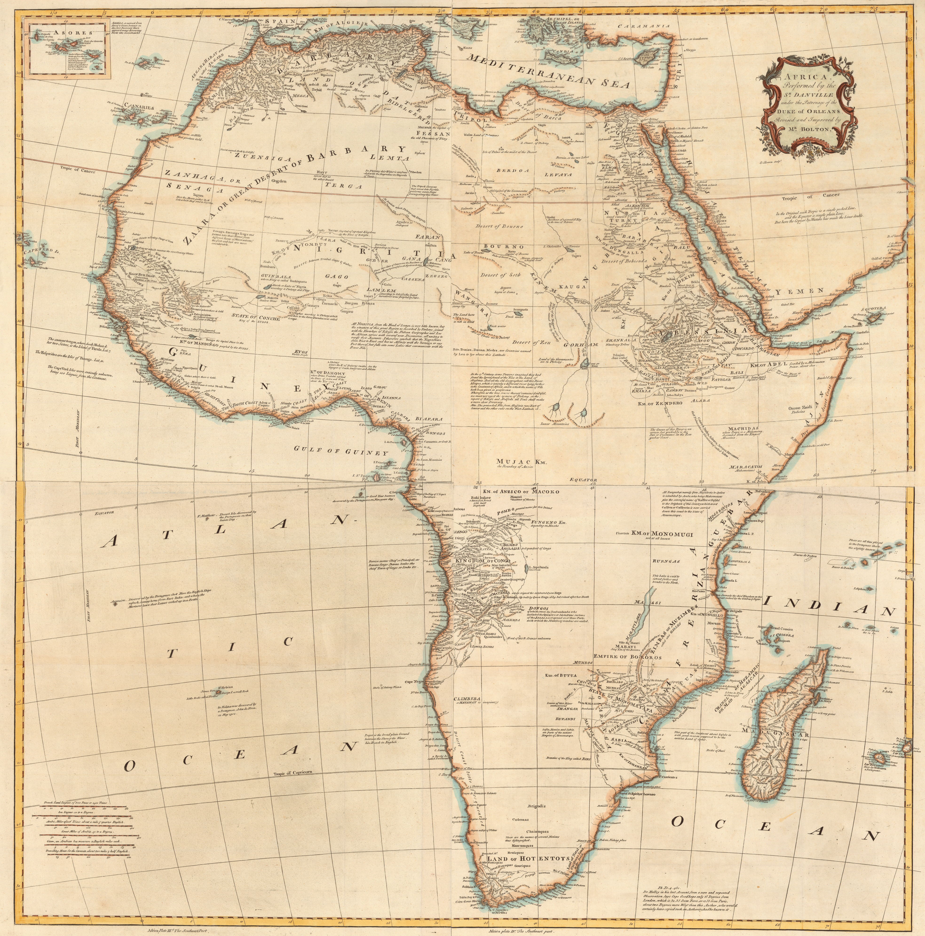
This map was a collaborative effort and shows the Kingdom of Judah in west Africa and Lamlem to the north as "peopled by Jews."
Link: Yale.edu Creator: Jean Baptiste Bourguignon d’Anville (Danville) Contributor: Emanuel Bowen, Solomon Bolton, Louis Philippe “duc d’Orléans”, and Malachy Postlethwayt Year: 1774 AD Title: Africa / performed by the Sr. Danville under the patronage of the Duke of Orleans ; revised and improved by Mr. Bolton ; E. Bowen sculpt.
BHITB and our affiliate sites are made possible by our sponsors. If you are interested in sponsoring an exhibit, please see our sponsor page for full details and benefits of becoming a sponsor. Click here to view our Sponsor Page.
1766 Duke of Orleans Map
Click The Map To Enlarge
More Info

Africa, plate Ist., The northwest part / examined and revised by Mr. Bolton — Africa, plate II, The northeast part — Africa, plate IIId., The southwest part — Africa, plate IV, The southeast part.

Appears in Postlethwayt’s Universal dictionary of trade.1

Sources
  1. Yale University. Africa / performed by the Sr. Danville under the patronage of the Duke of Orleans ; revised and improved by Mr. Bolton ; E. Bowen sculpt. https://collections.library.yale.edu/catalog/15512964 ↩︎

Share this:

  • Facebook
  • Twitter
  • LinkedIn
  • Reddit
*The Omnidex*, Forgotten Migrations Tags:1774 AD, Africa, Central Africa, D'Anville, Dahomey, Duke of Orleans, East Africa, Edrisi, Emanuel Bowen, Falasha Jews, France, Lamlam, London, Negroland, Nigritia, Ptolemy, Slave Coast, Solomon Bolton, South Africa, Transatlantic Slave Trade, Universal Dictionary of Trade, West Africa, Whydah, Yale University

Post navigation

Previous Post: 1743 AD: Homann Heirs Map of Juda On The West Coast of Africa
Next Post: Ethnonyms: Words That Describe Skin Color In The Bible

More Info Related To This Topic

1714 AD: Judaism Was the Religion of the Ancient Africans *The Omnidex*
1930 Allen H Godbey-Map of Africa 1930 AD: Map of Black Israelite and Black Jewish Communities Across Africa *The Omnidex*
Most Portuguese were tawny or black. 1760 AD: Most of the Portuguese Were Tawny or Black In West Africa *The Omnidex*
2022 AD: Igbo Declared Descendants of Ancient Israelites *The Omnidex*
880 AD: Eldad The Danite and The Lost Tribes In Africa *The Omnidex*
1864 AD: Congregation of Negro Portuguese Kidnapped And Sold Into Slavery *The Omnidex*

Contribute To This ExhibitCancel reply

Choose Your Language

My BookmarksShare

  • No bookmark found

Stay In The Loop

  • Academic Journal

Affiliate Sites

  • BHITB University
  • Hebrewsphere
  • JIHAAD.org

Resources

  • African Israelite Justice Foundation
  • Black Demographics
  • Slave Voyages
  • Internet Jewish History Sourcebook

Copyright © 2025 Black History In The Bible | #BHITB.

Powered by PressBook Blog WordPress theme


Loading Comments...
 

You must be logged in to post a comment.